Radar wiatru – mapa wiatru online na żywo dla Polski.
AirVeto to publiczny radar wiatru pokazujący wiatr w słupie powietrza od 80 m do 7 km — dla Polski, Litwy, Łotwy, Estonii i Ukrainy. Bez karty kredytowej, w przeglądarce.
Niedawne transgraniczne incydenty balonów i statków powietrznych.
Wszystkie zgłoszone wtargnięcia od grudnia 2025 — współrzędne startu, pole wiatru w danym momencie, trajektoria dryfu, miejsce lądowania. Z linkami do źródeł. Każdy wpis to osobna strona; możesz otworzyć dowolny moment bezpośrednio na żywej mapie w miejscu zdarzenia.

Romania F-16 shoots down drone - 24 July 2026
Romania's first drone intercept in its own airspace: F-16 from the 86th Air Base shot down an unidentified drone near Padina, Buzău county at 11:02 EEST on 24 July 2026.
Kotka Gulf of Finland drone alerts July 2026
Finland imposed four temporary airspace and maritime restrictions on the eastern Gulf of Finland between 2 and 18 July 2026, each linked to Ukrainian drone strikes near St Petersburg.
Kenas border outpost drone intercepted, July 2026
VSAT officers at the Kenas outpost heard a drone crossing from Belarus on the night of 17 July 2026 but couldn't find it in darkness. A dog handler located it the next morning in forest near Šumskų village, Vilnius district.Co pokazuje radar wiatru.
Standardowa prognoza wiatru pokazuje pojedynczą warstwę przy ziemi. AirVeto pokazuje pełny słup powietrza: kierunek i prędkość wiatru na ośmiu wysokościach — od 80 m (warstwa przyziemna) do 7 km (poziom lotów komercyjnych). Każda warstwa renderowana jest oddzielnie, co pozwala zobaczyć ścinanie wiatru, inwersje i korytarze, którymi obiekty unoszone wiatrem rzeczywiście się przemieszczają.
Dane pochodzą z Open-Meteo (model ICON-EU, rozdzielczość ok. 11 km, krok godzinowy). Mapa odświeżana jest co godzinę. Pole wiatru jest historycznie indeksowane — możesz cofnąć się do dowolnego dnia ostatnich tygodni i zobaczyć dokładnie tę samą prognozę, która była aktywna w danym momencie.
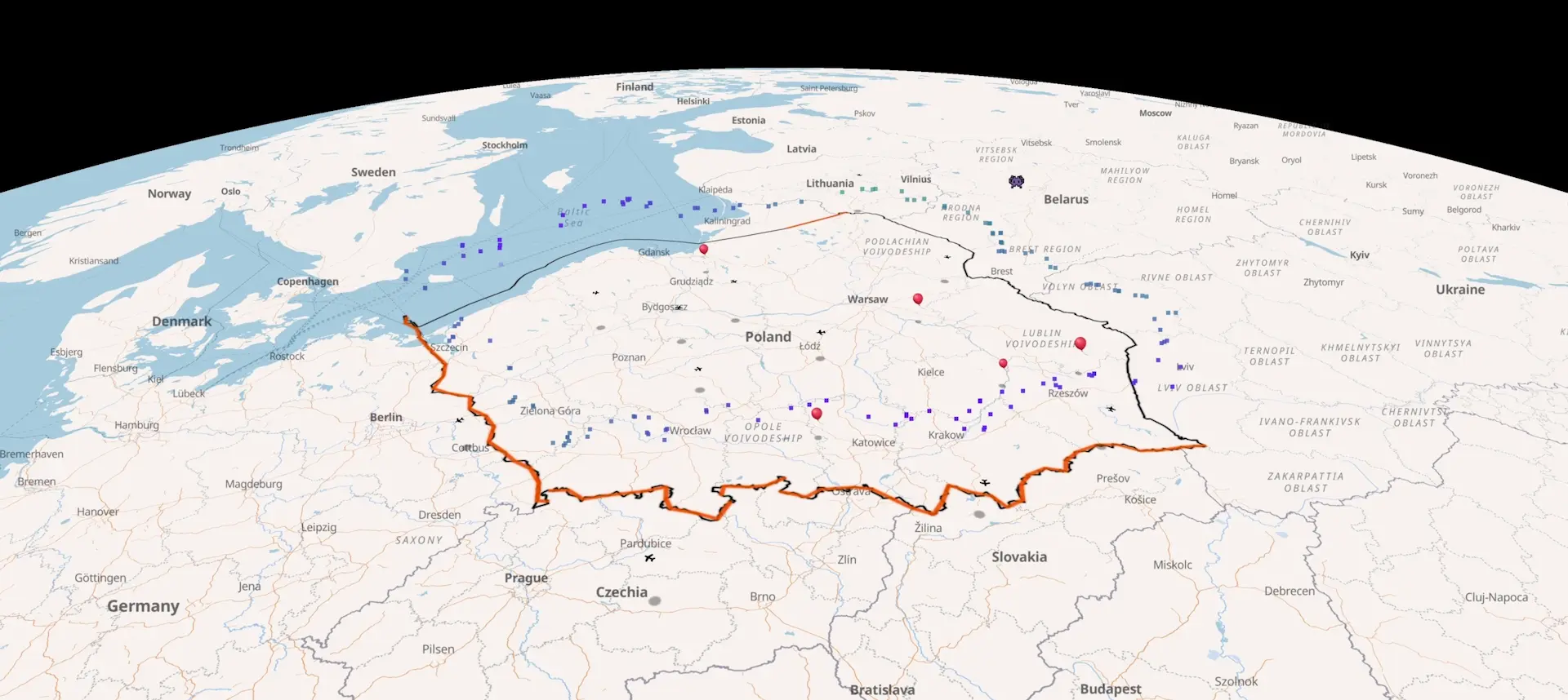
Polska i wschodnia granica UE.
AirVeto został zbudowany dla wschodniej flanki UE. Mapa obejmuje całe terytorium Polski — od granicy z Niemcami po granicę z Białorusią i Ukrainą — oraz Litwę, Łotwę, Estonię i ukraińską przestrzeń powietrzną. Trzy regiony są kluczowe i mają własne strony kontekstowe:
- Granica polsko-białoruska — najdłuższa lądowa granica UE z Białorusią. Wiatr z Białorusi przekracza ją regularnie i jest mechanizmem za incydentami z balonami przemytniczymi obserwowanymi od jesieni 2025.
- Przesmyk suwalski — wąski korytarz łączący Polskę z Litwą, jedyne lądowe połączenie krajów bałtyckich z resztą UE. Wiatry zachodnie i północno-zachodnie często przecinają go po skosie.
- Zatoka Fińska — wschodnia granica Estonii i Łotwy z Rosją, najbardziej wysunięty na północ odcinek granicy UE.
Do czego radar wiatru służy.
Radar wiatru AirVeto jest publicznym narzędziem OSINT-owym. Z mapy korzystają dziennikarze pracujący nad analizami incydentów lotniczych, badacze ruchu balonów przemytniczych, organizacje monitorujące wschodnią granicę UE, a także osoby śledzące pojawiające się obiekty w polskiej przestrzeni powietrznej.
Konkretne zastosowania: śledzenie korytarzy, którymi balony przemytnicze unoszą się z Białorusi do Polski; analiza, dlaczego dany lot komercyjny musiał zmienić trasę; rekonstrukcja, skąd przyleciał obiekt zauważony nad granicą. Każdy incydent w archiwum AirVeto zawiera mapę wiatru w punkcie i czasie zdarzenia.
Przykładowe incydenty zrekonstruowane na podstawie pola wiatru AirVeto:
- Kowno Szańce — ok. 9 000 paczek papierosów, 13 maja 2026 — balon przemierzył ~130 km z obwodu grodzieńskiego przy południowym wietrze na wysokości 3 km.
- Zamknięcie lotniska wileńskiego — 9 kwietnia 2026 — radar wiatru pokazał wschodni napływ na litewsko-białoruskiej granicy przez całą noc zamknięcia.
- Białystok / Podlaskie — 24–25 grudnia 2025 — pierwsza publicznie udokumentowana zgodność prognozy AirVeto z odzyskaniem balonów przez polskie służby.
Powiązane strony AirVeto.
- Mapa wiatru Polska — szczegółowy widok dla terytorium Polski.
- Kierunek wiatru — jak czytać kierunki na ośmiu wysokościach.
- Prędkość wiatru — odczyt w km/h i m/s, profil pionowy.
- Balony przemytnicze z Białorusi — OSINT przypadków transgranicznych.
Czego radar wiatru nie zastępuje.
AirVeto nie jest narzędziem nawigacyjnym ani źródłem informacji o bezpieczeństwie lotów. Pole wiatru to wynik modelu, nie pomiar bezpośredni — dokładność spada przy gwałtownych zmianach pogody i w pobliżu skomplikowanej topografii. Nie używaj AirVeto do planowania lotów, decyzji żeglugowych ani innych zastosowań krytycznych pod względem bezpieczeństwa. Pełna metodologia, znane ograniczenia i walidacja modelu opisane są na stronie /about/methodology.
Najczęściej zadawane pytania.
Otwórz radar wiatru.
Bezpłatnie, w przeglądarce, bez karty kredytowej. Mapa Polski, Litwy, Łotwy, Estonii i Ukrainy z wiatrem na ośmiu wysokościach.