Automātisks tulkojums · Galvenā valoda — angļu
Vēja radars un karte tiešraidē Latvijai, Lietuvai, Igaunijai, Polijai un Ukrainai.
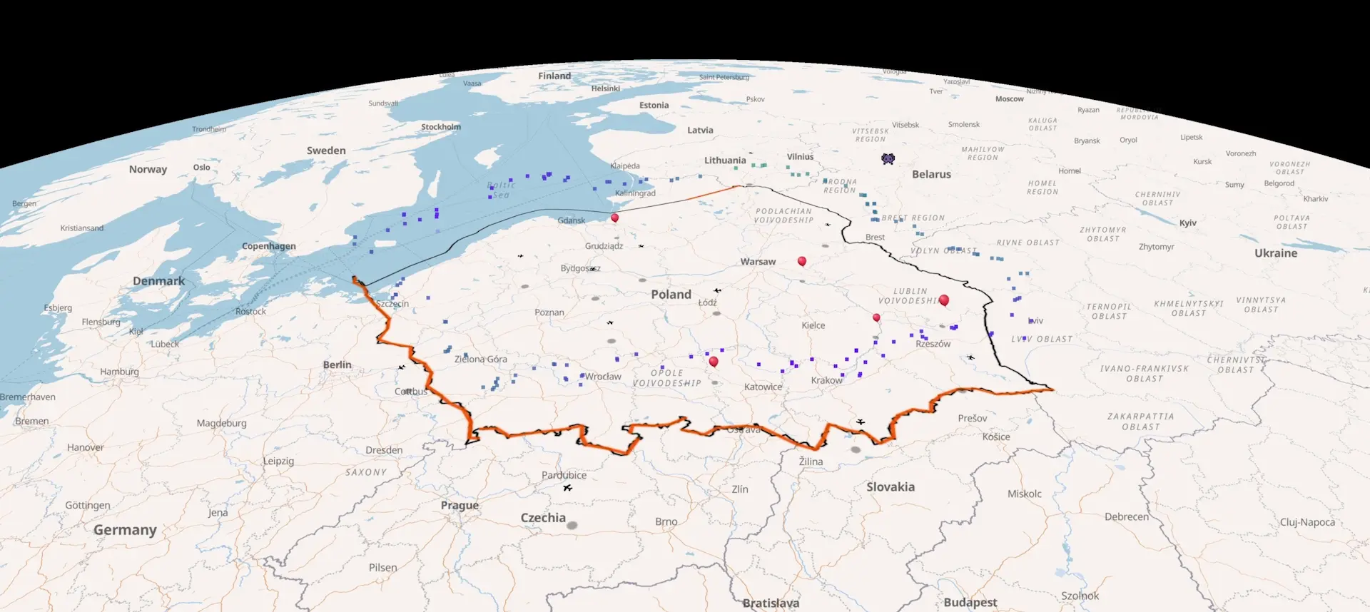
Tiešie vēja vektori vairākos augstumos, lidmašīnas (ADS-B) un kuģi Baltijas jūrā (AIS). Iezīmētie robežas posmi rāda, kur vējš pašlaik plūst no Baltkrievijas, Kaļiņingradas vai Ukrainas uz Latviju — koridorus, pa kuriem dreifē kontrabandas baloni.
Sign in with Google·No credit card required
Tiešsaistes vēja dati
Vēja vektori vairākos augstumos Polijā, Lietuvā, Latvijā, Igaunijā un Ukrainā. Atjaunināti katru stundu.
Lidmašīnu izsekošana
Tiešsaistes ADS-B lidojumi katrai kartē redzamai valstij plus AIS kuģi Baltijas jūrā.
3 dienu prognozePRO
Aplūkojiet nākotnes vēja modeļus un balonu drifta koridorus, pirms tie notiek.
Pielāgoti datiPRO
Pievienojiet savus ADS-B uztvērējus, AIS plūsmas vai sensoru datus tieši kartē.
Darbojas uz atvērtiem datiem
Nesenie pārrobežu balonu un lidaparātu incidenti.
Visi ziņotie pārkāpumi kopš 2025. gada decembra — palaišanas koordinātes, tā brīža vēja lauks, dreifa trajektorija, piezemēšanās vieta. Ar avotu saitēm. Katrs ieraksts ir atsevišķa lapa; jebkuru laika zīmogu var atvērt dzīvajā kartē notikuma vietā.

Romania F-16 shoots down drone - 24 July 2026
Romania's first drone intercept in its own airspace: F-16 from the 86th Air Base shot down an unidentified drone near Padina, Buzău county at 11:02 EEST on 24 July 2026.
Kotka Gulf of Finland drone alerts July 2026
Finland imposed four temporary airspace and maritime restrictions on the eastern Gulf of Finland between 2 and 18 July 2026, each linked to Ukrainian drone strikes near St Petersburg.
Kenas border outpost drone intercepted, July 2026
VSAT officers at the Kenas outpost heard a drone crossing from Belarus on the night of 17 July 2026 but couldn't find it in darkness. A dog handler located it the next morning in forest near Šumskų village, Vilnius district.Mūsu galvenie reģioni.
Pārklājums koncentrēts gar ES austrumu malu — sauszemes un jūras robežām starp dalībvalstīm un Krieviju vai Baltkrieviju.
SauszemeSpraugaEksklāvsLidosta · EYVIJūra · BaltijaBaltija
Polijas–Baltkrievijas robeža
Garākā ES sauszemes robeža ar Baltkrieviju. Pēdējo migrācijas un gaisa telpas incidentu epicentrs.Suvalku sprauga
Šaurs koridors, kas savieno Poliju ar Lietuvu — un vienīgais sauszemes savienojums starp Baltijas valstīm un pārējo ES.Kaļiņingrada
Krievijas eksklāvs, ko robežo Polija un Lietuva — tuvākais Krievijas kontrolētās teritorijas punkts pie Suvalku sprauga, 20 km uz rietumiem.Viļņas starptautiskā lidosta
Galvenā Lietuvas lidosta, 30 km no Baltkrievijas robežas — slēgta vairāk nekā desmit reizes balonu ielaušanās dēļ kopš 2025. gada oktobra.Somijas līcis
Baltijas jūras atzars starp Igauniju un Somiju, no austrumiem robežojas ar Krieviju — blīva AIS satiksme, GPS traucējumi un nomaldījušies droni.Baltijas–Krievijas robeža
Igaunijas, Latvijas un Lietuvas austrumu malas — vistālāk uz ziemeļiem esošā sauszemes robeža starp ES un Krieviju.Atveriet karti tiešraidē.
Sign in with Google·No credit card required